Ellicottville Mountain Biking Trail Map v1.14
 I have updated my map of the mountain biking trails around Ellicottville to include Golden Hills and Allegany State park. I have also created an installer for easy installation and have an experimental release for my friends with Macs.
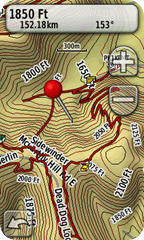
This map has a transparent background, so you can load it and it will show on top of your other maps. I would recommend Garmin’s Topo US 2008, or if you want to save some money, the excellent free NY Topo. This map is for Garmin GPS devices only and can be loaded into their free MapSource software. If you don’t already have MapSource installed, you will need to follow the instructions here to install.
Thanks to Jon Sundquist for the Allegany State Park information.
Downloads
The Apple version of the map is untested. Please let me know if it works.
Please send feedback, corrections and updates to rob (at) prouse (dot) org. You can send new trails in GPX format, but I can handle most common GPS file formats. If there is enough interest, I will try to release the maps compiled for other GPSs.
The maps are for reference only and contain inaccuracies. Data for the trails comes from many sources and all have not been verified. Trails also regularly get re-routed, trails are closed and new trails are opened. I’m not responsible for how you use the data, or any inaccuracies.
